Monday, October 30, 2006

Just When you start getting used to the warm............


Well…I should of stuck with my original foreacast of the rainstorm being a Friday Event. I mistimed it and as it turns out it rained on Friday and Friday night and was Sunny on Saturday. The high winds however did verifiy. Was a much better forecast from long range than it was from short range.

Anyway…what now? Well we warm up very nicely Monday and Halloween as I have been emphaszing but by this weekend, we get our coldest shot of the season and it will last a few days. Very Impressive Arctic Air Mass will have next weekend feeling like early December.

After that 3 day cold shot, we will moderate nicely once again. So definetely a roller coaster pattern. This looks to be a pretty dry week too.

Friday, October 27, 2006

Preview of the upcoming Storm!


Impressive Storm For this Weekend

Another Powerful storm is on the way...are you seeing the trend of stormy/below average weather?

Here are 5 things to look for with this event

1) Drenching Rains-look for 2 inches plus in the I-95 Corridor
2) Big time Winds once the storm passes. Look for Wind Gusts up to 40 mph
3) Heaviest Rain Friday night/Saturday Morning. Should clear out now by late Saturday Afternoon in DC. For the Northeast Corridor..mostly an all day Saturday Event.
4) Very Cold behind the storm. Saturday Night will be very cold with big time wind chills. Wind Chills will easily be in the 20's on Saturday night. Dont be suprised to see a flake.
5) Moderation begins on Monday. Halloween looking very pleasant

Next week will feature a bit warmer weather but then we may have to deal with another Shot of Very Cold air around Nov 2-3.

Wednesday, October 25, 2006

Time to cash in that raincheck


In my monday post, i thought the heavy rain would come Friday. The models are now showing the powerful storm approaching about a day later than I previously thought so yes...we are looking at a very rainy saturday. We could see about 2 inches of rain on Saturday with Heavy Rain most of the day. It will also be chilly and Windy as the storm center passes right over us. After this storm passes..i do see somewhat of a moderation in temps to about normal. Right now Halloween looks to be dry and seasonable.

Monday, October 23, 2006

10 Things to Look for this Winter

Well, the big chill is here. Hope you were ready for it as I gave you over 10 days advanced warning. This week as I mentioned will be much below normal and now eyes are on a potential big storm for this Friday which could give the I-95 corridor another big rainmaker. The storm will become a polar vortex once it passes and usher another shot of really cold air. This cold air could be enough to support snowshowers/flurries on Saturday from Northern Virginia North. But dont worry, there will be a moderation towards the end of October.

Now with Winter coming up...Here are 10 things that will define this winter.

1) It will be a stormy winter. El Nino winters are known for being very stormy. Dosent mean every storm is snow but it will be an active winter with lots of events.

2) It will not be a historically cold winter. The earth has been getting warmer and the stats back it up. We just had the warmest winter and summer in recorded history so getting historically cold weather will be very tough. Nothing that we cant handle this year.


3) December will be the warmest month of winter relative to Normal.


4) January will be the coldest month of winter relative to normal. Last year was a historically warm January. I think this year January will be cold and stormy.


5) January and February will be very snowy. Dont be surprised if we dont have much snow heading into January. The snow will come and will come often.


6) There will be at least one severe Winter Storm this year. Most El Nino winters feature a storm for the record books. Look for one like this in January or February.


7) When it gets Warm, its going to get really warm. This winter isnt all about snow and cold. There will be some warm spells and they could be record breaking warm spells due to the strength of El Nino and the overall warming that we have been seeing recently.


8) Expect alot of Mix Events. IF you live In or South and East of the big cites like Washington,Philly, expect alot of storms to start as snow and change to rain or mix. With El Nino, you have a tendancy for very powerful storms which tend to wrap more warm air on the east side of the storm. If you live N and W like Hagerstown,Fredrick,Allentown, PA, you could be in the bullseye of alot of storms.


9) There will not be a White Christmas this year but maybe a White New Years


10) the DC screw. This happens every winter so no suprises but DC will find a way to screw up a winter storm or two.

Thursday, October 19, 2006

Cold End To October

Despite yesterdays sultry 78 degrees at Dulles Airport, October will probably finish below normal because starting tomorrow till the end of the month, most days will struggle to reach Normal. The heart of the unusual cool will be during the early part of next week where temps might be 15-20 degrees colder than normal. So far in October, temps are about normal to slightly below, but by the end of the month, I am confident we will finish safely below normal giving us our 2nd month in a row like this. This is significant because it’s been a long time since we have had 2 months in a row with below normal temps. As a matter of fact, 14 of the last 15 months have been above normal and last winter and this past summer was considered the warmest ever recorded in the United States. This is also significant because I am predicting a snowy and colder winter than we have seen in while.


Anyway…enough of the stats. A storm brewing in the Gulf will track west of the I95 corridor(A great track for Ohio Valley snow if it was winter) giving us a good chance for severe weather tomorrow .The heavy more widespread rain will be mostly in the Ohio Valley. Once the storm passes, colder air will slow start spreading east. This weekend will be nice but you will really start to feel the chill by Monday.

Monday, October 16, 2006

Big Rainmaker for Tuesday


See that big batch of rain? This is our next weather maker as it will give us a a soaking Tuesday. Rain should start tomorrow morning near rush hour and continue all day and through the evening. The Rain will be heavy at times and give everyone in the I95 corridor from DC all the way to Boston.

After the rain, we will warm up for a few days thanks to the big ridge setup in the Gulf. But after that, another cold front is going to usher a reinforcing shot of cool air. The last week in October looks unusually cold and would not be surprised if we saw our first flakes.

Saturday, October 14, 2006

Similar Story setting up for this Week


Models in agreement that a big ridge in the southeast/gulf coast will keep most of the wintry action and cold weather in the Western/Northen Parts of Canada and the United States.However by next weekend, a similar setup will occur when a big storm heading towards the Lakes will usher in cold air ro the East Coast. Still have to see if this storm comes closer to us and possibly giving us more rain than last week.

The next cold shot will be colder and have more staying power but at least for this coming workweek...enjoy the moderation.

Friday, October 13, 2006

Ji's official 2006-2007 Winter Forecast-From Sept 19

I feel pretty confident about this forecast so I am issuing it early. Last year I went for a pretty ho hum winter and that’s pretty much what we got except it was warmer than I thought because of record breaking warm January. This year, I predict winter returns in a big way

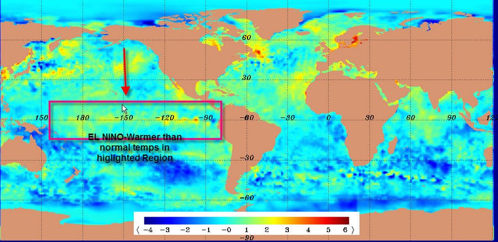
This is clearly going to be a weak to moderate El Niño winter. El Nino is based on the Pacific temperatures in the region that I have highlighted in the map below. The map basically shows if the ocean temps are normal, below or above normal. For us to have an El Nino we need temps to be warmer than normal in the region I have highlighted in red square which it clearly is right now. Also look at the warmer than normal temps in the Gulf of Mexico. This is a good indicator for storms brewing in the winter. Storms love warm water. If a hurricane came into the Gulf right now, it would be ripe to become another Katrina based on the Gulf of Mexico temps


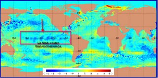
On the flip side, last year we had a La Nina Winter as temps in the same region were much colder than usual. Usually La Nina means a drier and warmer pattern for the Northeast/Mid Atlantic and snowier for the west coast which is pretty much what happened last year as January soared to record highs


But this year is an El Nino Winter. DC and the northeast seems to cherish these kind of winters as they seem to be the snowiest. We have had some very snowy winters during el Niño seasons like 1986-1987, 1977-78,1976-1977,2002-2003, 1965-1966,1963-1964,1957-1958. These were considered weak to moderate El Nino’s

Other El Niño winters in 1987-1988, 1969-1970,1968-1969.. They also featured above normal snowfall although those winters were not as severe as the ones I listed above. When I say good or outstanding winter, I mean snowy and cold. Other people have different views of what a good or outstanding winter is:)

We have also had some El Niño winters that were very warm like 1994-1995 and 1991-1992 and 1997-1998. Those were very strong El Nino’s in which the temps in that region which I have higlighted in the graphics were way above average. Strong El Nino’s are known for very stormy and very warm winters. El Nino’s are a whole are known to be stormier than normal. 1997-1998 was the strongest El Nino ever recorded! DC and Philadelphia combined got less than an inch of snow but it was plenty stormy.

But its not a coincidence that most el Niño winters for the Mid Atlantic and Northeast make winter lovers happy. There have only been a few that have been warm so I am playing the odds with this forecast.

I am also taking into consideration the recent warm spell of the past year or so and how we have struggled to be below normal at all for any month. I also realize how fast you can go from a warm winter to a cold winter ala 2001-2002 which was a La Nina and very warm to 2002-2003 which was an El Nino and very snowy.

With that being said....here we go

December Normal temps. December will most likely start warm and by Dec 15-20 turn cold and stormy
January -2.5 below normal. Cold, Snowy January
February -1.5 below normal
March +1.0

Snowfall for DCA: 20-23 inches. BWI 25-30 For IAD: 30-35 inches. Boston,Philly and NYC should all get snow 5-10 inches above normal. The N and W suburbs have a banner year and this year feels like a classic again. This will not be a repeat of 02-03 but it’s going to be a really good winter! And of course, one blizzard cly stand out. Enjoy your last days of Summer

Warmup Next week but possible Rainstorm and another Cold shot by Next weekend.

Well the cold came as advertised. Temps dropped to around freezing in the Northern and Western suburbs. I had to actually scrape ice of my car today. Tonight will be even colder than last night although we should start seeing a slight moderation by later on this weekend. We actually didnt even come close to getting the full brunt of the cold air as the actual storm cut towards Canada. Parts of the Upper Midwest got tatooed with snow and many records were set for snowfall in towns like Chicago,Detroit and Buffalo. As a matter of fact, Buffalo got 8 inches of snow and some of its suburbs got up to 2 Feet!

Next week, temps should rebound and be at normal or slightly above normal as trough sets up in the west and a Ridge in the setup near the Gulf of Mexico keeps us mild This is a great pattern for getting snowcover in Canada which plays an important role in the winter. However by next weekend, another storm will come through dropping more snow in the upper Midwest/Lakes area and ushering below normal cold air. The last week of October will feel like the last week of November with below average temps.